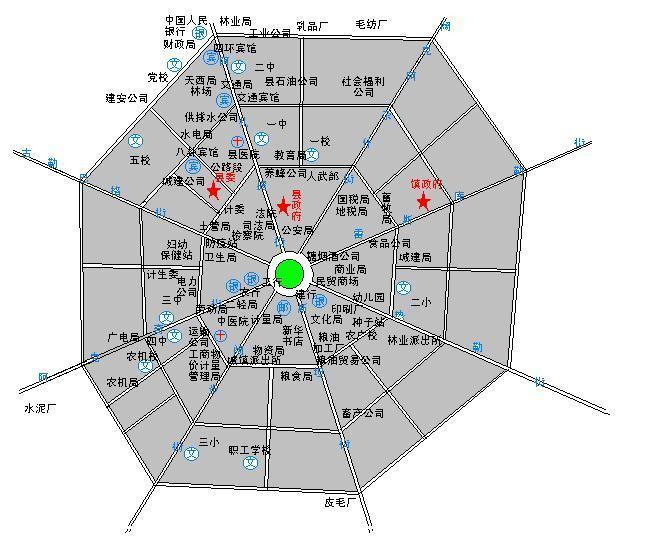
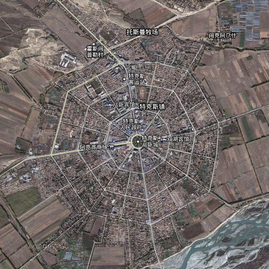
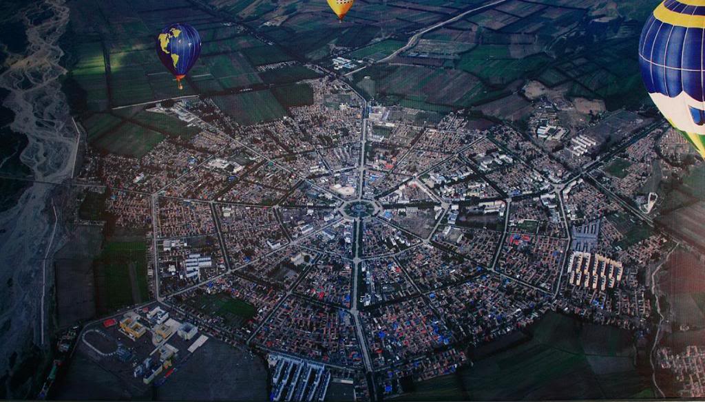
1938年2月,原縣府所在地科布前面臨河、後面靠山,地域狹窄,難有大發展。當時任伊犁屯墾使兼警備司令的邱宗浚到特克斯親自勘查,按照易經八卦的形制建造八卦城,以放射狀的4環、64條街路路相通。1939年夏,在時任縣長班吉春的指揮下,聘請前蘇聯水利技術人員幫助測量和打樁放線,用二十張牛犁沿著八卦圖的八條射線犁出八卦城街道的雛形。當年10月22日,八卦城建成,縣政府正式遷入辦公。城市的現代病「擁堵」在這裡不存在。
2004年,特克斯縣城被新疆維吾爾自治區政府列為自治區級歷史文化名城(第一批),2007年被國務院列為國家歷史文化名城]。特克斯縣相規定在四環以內不准建5層以上建築,以保證在觀光塔上一覽縣城全貌。2009年7月又新建了八卦公園並設「大易碑廊」,將易經的三種版本刻於廊上,以弘揚《周易》文化[。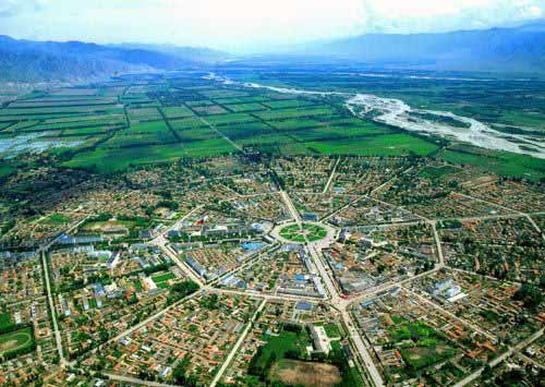
特克斯縣是中國新疆維吾爾自治區伊犁哈薩克自治州所轄的一個縣。位於伊犁河上游的特克斯河谷地東段。
Tekes County is a county within the Xinjiang Uyghur Autonomous Region and is under the administration of the Ili Kazakh Autonomous Prefecture. It contains an area of 8,067 km2. According to the 2002 census, it has a population of 150,000.

 The Eight Diagrams City belongs to the Ili Kazak Autonomous Prefecture, located in the northern foot of Tianshan Mountain West, south of the Wusun Mountain, Tezhao eastern basin, with a total area of 8352 square kilometers, 815 kilometers away from Urumqi, Yining City, and 116 kilometers away.
The layout of this city was made in the traditional eight diagrams or octagonal pattern. With the square as the center, eight equiangular thoroughfares extend toward eight different directions. Intersected by a number of ring roads, these streets thus form a clear eight-diagram pattern. The eight straight thoroughfares actually came from eight equiangular furrows ploughed by eight oxen when the city was first built. The eight equiangular furrows were later widened to become eight thoroughfares. Design work started in 1937 and construction started in 1939. It is the largest and most typical Eight Diagrams city in the world.


